This year, 2015, has been full of a lot of new changes here at "The cabin".
Started a new job in January with the Postal Service. All is going well there, I am just plugging along waiting my turn to be "made regular", which means I become a career postal employee, not a contractor.
Purchased a nice home big enough for my family to stretch out in and live life. Grounds keeping and general maintenance keep me busy at home.
Still an active den leader of the Cub scouts, boys are growing and learning but they sure aren't slowing down anytime soon!
Here's wishing you and yours a Merry Christmas and Happy Holidays!
Wednesday, December 9, 2015
Sunday, January 4, 2015
NCT trip planning Part 1
Hey folks,
I hope your year is off to a good start. Mine sure is, I start a new career on the 5th so I am pretty excited.
Anyway, this past week off I had time to do some of the planning for a trip I have wanted to do for a couple of years now. A hike on the North Country Scenic Trail. This entry is just going over the maps and paperwork planning and that sort of thing. My gear planning, food and clothing will be along in future posts.
I've talked about it before but to give a quick recap it is a trail, very much like the Appalachian Trail. The NCT stretches from North Dakota to New York State, not as popular as the AT just yet but it is longer. The trail cuts through Minnesota in the Northern part of the state, passes through part of the Boundary Waters Canoe Area and skirts Lake Superior before slipping off in to Wisconsin and points East.
The terrain where it cuts through was formed during the last ice age as was much of Minnesota including our famous lakes. A large portion of the trail section I plan to hike follows an area that was created by the leading edge of glaciers that covered this part of the earth so long ago.This terrain is called moraine and what it means is the area is a mix of varied elevations,bogs and lakes, and some rolling hills. I've spent a lot of time in this part of the state since my family cabin is right there and I am familiar with the ground and excited to see more of it step by step.
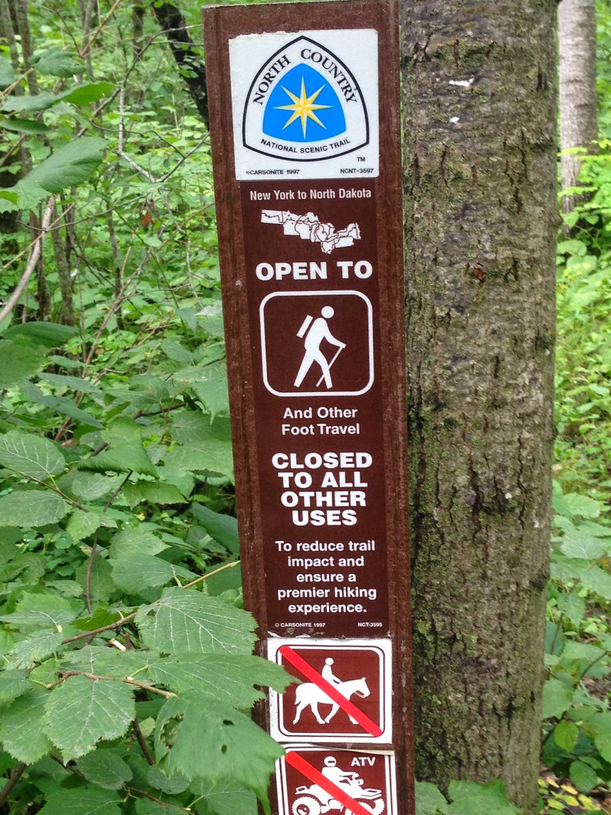
The blue blaze on the tree in the above picture is the official trail marking of the NCT. Hard to tell in the picture but in this stretch the trail is just about 8 feet wide.
I've done some research now, online through the NCT websites and forums, they even have a face book page for the Minnesota Chapters a great resource to get area specific questions answered by folks that not only hike the trail but help maintain it. I was able to purchase maps covering the areas I am interested through them as well. Give their page a look for more information at North Country Trail or visit the Minnesota chapters face book page here.
So, I sat down with the 2 maps and a great guide book "Guide to the North Country Scenic Trail in Minnesota" put out by Big Earth Publishing Company and planned a route. The book is an excellent resource covering every aspect of the trail here in Minnesota. Mile for mile including service cities, access points and trail heads, interesting features etc...
I quickly found several easy day hikes available to me in the area I want to hike, close to my cabin and family if needed. I decided to plan a grand adventure of a week long trip. I expect to spend 5 days (4 nights) on the trail covering about 45 miles of it in total. This would basically just press several of those day hikes into one long one. I know some experienced hikers can do 45 miles standing on their heads but this is a first for me. The last time I put on any serious cross country foot miles I was in my early 20's and a young Infantryman. All along my planned route are what I call "bail out points". Trail heads, parking lots, small towns, highway crossing and such. Places I know I can get to that have good cell service so I can make a call if needed and get help. I'm not planning to fail but I think knowing where my outs are if I need them is important.
Route selection. It seems to make sense to start and stop at some kind of landmark that is hard to miss. The start point was an easy choice, the South Parking lot of Itasca State Park. The trail cuts right through the park and this lot. Itasca State Park is also the Headwaters of the Mississippi river and sees thousands of visitors each year. The end point will be at a camping area in The Chippewa National Forest right off Highway 34 between Akeley and Walker Minnesota, again, lots of traffic and visitors.
As an aside a hike of the trail across Itasca would be a great day hike and maybe even a good meetup for folks from the Bush Craft USA forums
Day One: South parking lot of Itasca State park East to the Amikwik campsite, about 12.9 miles. It's the first day so I will be fresh, this is the longest leg of the hike. The campsite should have 3 tent sites a fire ring and a privy and over looks a beaver pond. I will be filtering and boiling any water I collect on the way. Amikwik is Ojibwe for Beaver
Day Two: Amikwik campsite to the Nelson lake/Gulch Lake campsite, about 7.9 miles. Gulch Lake is a state run campsite, I will need to pay to camp here. 3 campsites, and other facilities available.
Day Three: Nelson/Gulch lake to Waboose Lake campsites, this section heads almost straight south. 9.7 miles Another established campsite with tent pads, fire rings, etc... Second longest leg of the trip. Waboose means rabbit in Ojibwe.
Day Four: Waboose lake back Eastward to Sprinkle Lake Road campsite about 7.3 miles. 4 tent pads, fire ring and privy. The campsite is on a spur 60 feet off the trail.
Day Five, last leg: Sprinkle Lake Road campsite 6 miles to the Shingobee recreation area of the Chippewa National Forest, my pick up point. After pick up a celebratory meal in Walker then 45 minutes back towards Park Rapids and th cabin for a weekend of recovery at our lake.
As I said none of these legs are very long or challenging, this is a relaxing trip. I left lots of time and hopefully energy to be able to stop and explore along the way.
Thanks for following along so far!
Saturday, January 3, 2015
Happy New Year!
As I was Up North visiting my parents during the New Year holiday I took the opportunity to get out on new years day for a quick day hike. Original plan was to go solo but my oldest daughter, and then my Step Father and Comet (his labradoodle) tagged along as well.
They live out by the airport in Bemidji, MN. cross their street is a big patch of stat land and some potlatch owned land as well. In short a nice little woods to walk through.
The temp for our hike was in the 20's and over cast. A slight wind but all together not too bad at all. I grabbed some survival kit stuff for my pockets, my water bottle and my Turley Green River knife and off we went.

Ok, in the above pic is the kit that I brought with. there are some gaps, calculated risk given that I was within 1/4 mile from home and everyone at home knew exactly were we were going. Cell service was excellent as well.
Top left is my orange REI Nalgene. orange so I can see it out in the woods when I set it down. Next is a little altoids kit: Wolf Creek Forge knife, exotac nanotstriker, boullion cube, 3 PJC's, some bandaids, a bic lighter and about 12 square inches of tin foil. A zebra mechanical pencil I just happened to have in my pocket. Finally a piece of an old army VS-17 signal panel about 18" wide by 3' long. As you can see it's blaze orange on one side, the reverse is hot pink. Very visible especially in winter conditions when the world turns pretty drab.
Upper middle is an emergency blanket and a UCO stormsafe match box with lifeboat matches inside. Next to that is a signal mirror I have been carrying since my days in the Infantry in Alaska. Below that is a piece of wetfire tinder, my SAK farmer with a ferro rod attached and, of course, the Turely.
In hindsight I should have grabbed the 25' coil of 550 cord I brought up too since I had room for it. I also need to get a nesting SS cup for that nalgene, that has been a need of mine for a while and I will be addressing it very soon with an REI gift card I got as a Christmas present.
Ok, gear all set and off we went!


Water Bottle fit perfectly in my Bushcrafters dump pouch by Badger Claw Leather works, thanks again John! You can also see how bright that panel is sticking out above my pocket.
We set out down the trail, with the 2 dogs with us finding any other animal tracks was tough but we managed a few.


The dogs quickly found some predators left overs,just hidden under a thin blanket of snow.

Hard to see in the following pictures but we found, rabbit, partridge and mouse tracks.
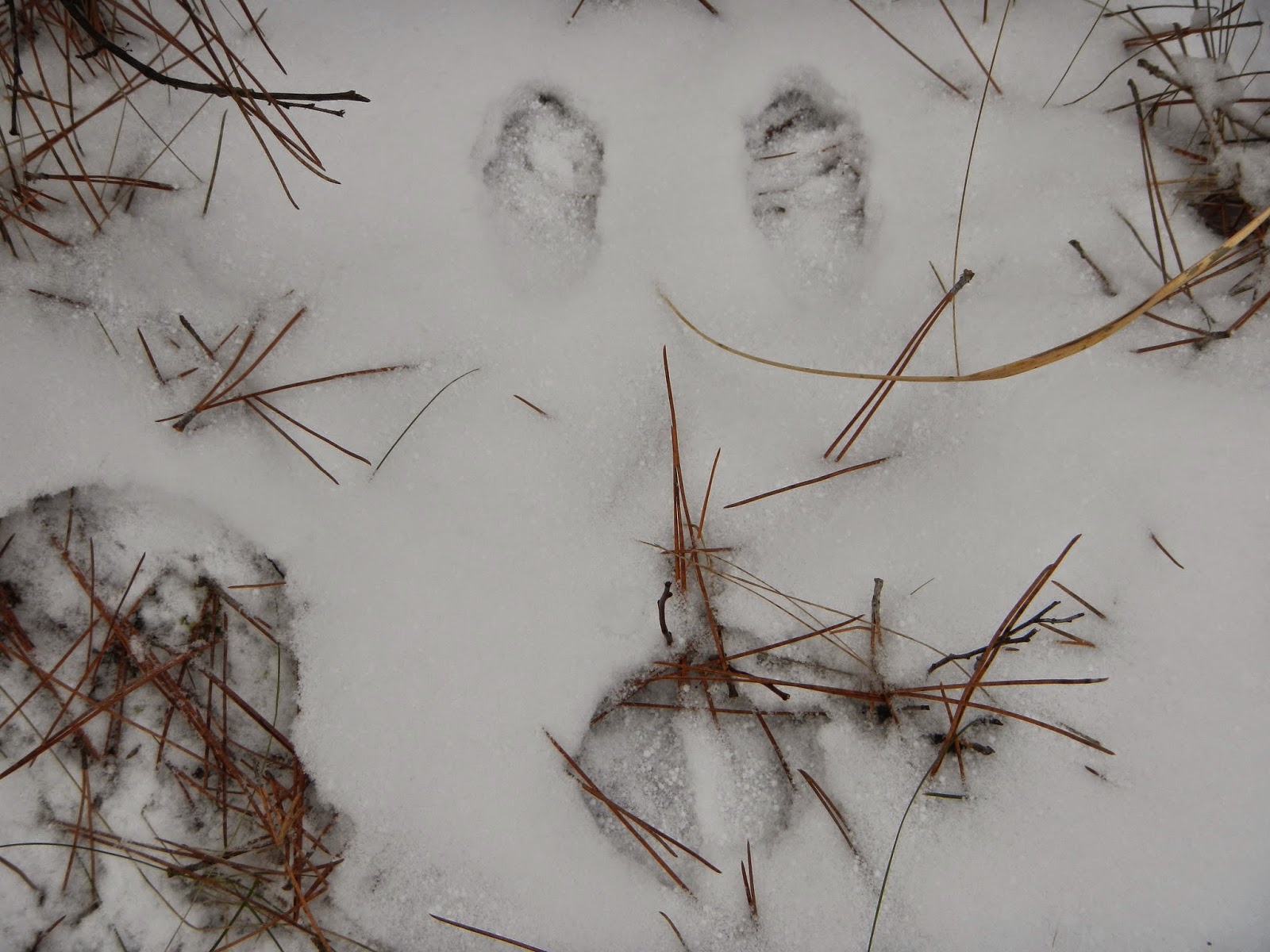


Comet, our companion, runs about 90 lbs. He's what I would call a pretty good sized dog. Here is a shot of him and one of his print next to my hand for a size reference. If I come across another variety of canine track in the woods be it wild or domestic, at least I can gauge it's size a bit better. We do have coyote and wolves in this area and the area of our cabin which is about an hour south near Park Rapids.


I didn't set out to practice any skills, just get out in the clean cold air and enjoy a little hike. In that respect I was a success. The fact that my video game centered oldest daughter volunteered to come along and spend time out with Dad (and Grampa and the dogs) means it was an unparalleled success. I'm always happy to spend time out in nature and when I can share that with my loved ones I cherish the time even more.
I hope everyone can get out this year and enjoy the wilderness and nature, even if its just a small hike with your loved ones.

As I was Up North visiting my parents during the New Year holiday I took the opportunity to get out on new years day for a quick day hike. Original plan was to go solo but my oldest daughter, and then my Step Father and Comet (his labradoodle) tagged along as well.
They live out by the airport in Bemidji, MN. cross their street is a big patch of stat land and some potlatch owned land as well. In short a nice little woods to walk through.
The temp for our hike was in the 20's and over cast. A slight wind but all together not too bad at all. I grabbed some survival kit stuff for my pockets, my water bottle and my Turley Green River knife and off we went.
Ok, in the above pic is the kit that I brought with. there are some gaps, calculated risk given that I was within 1/4 mile from home and everyone at home knew exactly were we were going. Cell service was excellent as well.
Top left is my orange REI Nalgene. orange so I can see it out in the woods when I set it down. Next is a little altoids kit: Wolf Creek Forge knife, exotac nanotstriker, boullion cube, 3 PJC's, some bandaids, a bic lighter and about 12 square inches of tin foil. A zebra mechanical pencil I just happened to have in my pocket. Finally a piece of an old army VS-17 signal panel about 18" wide by 3' long. As you can see it's blaze orange on one side, the reverse is hot pink. Very visible especially in winter conditions when the world turns pretty drab.
Upper middle is an emergency blanket and a UCO stormsafe match box with lifeboat matches inside. Next to that is a signal mirror I have been carrying since my days in the Infantry in Alaska. Below that is a piece of wetfire tinder, my SAK farmer with a ferro rod attached and, of course, the Turely.
In hindsight I should have grabbed the 25' coil of 550 cord I brought up too since I had room for it. I also need to get a nesting SS cup for that nalgene, that has been a need of mine for a while and I will be addressing it very soon with an REI gift card I got as a Christmas present.
Ok, gear all set and off we went!
We set out down the trail, with the 2 dogs with us finding any other animal tracks was tough but we managed a few.
Comet, our companion, runs about 90 lbs. He's what I would call a pretty good sized dog. Here is a shot of him and one of his print next to my hand for a size reference. If I come across another variety of canine track in the woods be it wild or domestic, at least I can gauge it's size a bit better. We do have coyote and wolves in this area and the area of our cabin which is about an hour south near Park Rapids.
I hope everyone can get out this year and enjoy the wilderness and nature, even if its just a small hike with your loved ones.
Subscribe to:
Posts (Atom)